Date: 4/10/14
River: Ashley River, Canterbury, NZ
River Conditions: 5.1 cumecs at Ashley Gorge. Water clear, swift and cold. Grade 2.
Weather Conditions: Cool but sunny, overcast with light snow (hail) later.
Number on Trip: 7 people.
Time on River: 3.25 hours. Comments: Being unable to go one the club trip on Sunday and after being teased unmercifully at the WWCC drinks on Friday for paddling the Ashley at 6 cumecs last weekend, Graeme decided to go one better and do it at 5 cumecs and make the most of a sunny day. As I was up until 1am on Friday night (not at the club drinks) and I wasn’t exactly sure what the weather was going to be like, I held off fully committing until the morning, but the sky looked clear and the forecast good, so the boat went on the car and I drove off to The Peg.
There were seven of us there and so we took three cars and drove to the middle bridge to get changed. It was cold but sunny and looked like being a very nice day, even if the flow was a little on the low side. We ended up chasing another sheep down in to the Lees Valley after she refused to leave the road or let us past, we think she was racing us. Once on the river, we bounced our way down to the Townsend confluence and the played, caught eddies and generally enjoyed the river as we made our way down stream. This time I made sure I kept my nose clip on and didn’t get too cocky so there was no repeat of last weekend’s embarrassing incident. At the main boulder garden rapid, I managed to spot the wire fence tangled around the large rock about half way down on the river right, the fence trails off down stream before disappearing below the water’s surface. It didn’t cause any problems for our group but there is definitely the potential danger there, so be careful if you do this run.
Surfing on the Upper Ashley. Photo by Steffan
There were the odd rolls and swims, but it was great to see people trying new things, pushing their limits and challenging themselves. Prasasta wowed us all when she tipped whilst surfing a wave, then rolled up again while still surfing the wave, we all cheered as it was pretty awesome. Contrary to some opinions, there was plenty to do and only rarely did we find the bottoms of our boats touching the stony river bed and then only on the occasional gravel chute, where the river widen or was braided.
As we near the end, the sky darken and it grew noticeably colder and then began to snow. Not the light, feathery flakes but more rounded and probably closer to hail but more airy, it was quite pretty but it didn’t settle and fortunately stopped before we reached the get out. We got changed, covered up against the sand flies and the cold while the shuttle was run. Then headed back to town via a stop at Seagar’s for a coffee and a nibble. Another fun and tiring day out, time better spent on the river than in a mall.
Date: 27/09/14
River: Ashley River, Canterbury, NZ
River Conditions: 6.2 cumecs at Ashley Gorge. Water clear, swift and cold. Grade 2.
Weather Conditions: Cool and overcast.
Number on Trip: 3 people.
Time on River: 2.5 hours. Comments: With the club heading to the West Coast and a first aid course on Sunday, we needed to do something on the Saturday to get a trip in. Graeme was keen, so he, Brent and I met up at the The Peg at 8am with the basic plan to run the Hurunui from Jollie Brook down to Seaward. We’d checked out the weather forecast, which didn’t look good and also noted the sharp upward kick of the flow gauge at Mandamus, which was show 55 cumecs at midnight and rising. The upper section of the Ashley was suggested and we all agreed that this looked like a better plan for our small group, with the shorter drive meaning we would be off the river before the weather turned as well. So after getting my boat on Graeme’s car, it was off to the middle bridge, before getting changed and driving to the Lees Valley put in.
The first part was a little bumpy, but once the Townsend River joined the flow, the going got better. With the low flow, I adopted a slightly more relaxed style, removed my nose clip and loosened my technique somewhat and as a result found myself upside-down with a head full of water in a rather shallow spot, after a little casual play went awry. As I was almost touching the bottom or some rocks, I tried to lift myself up using them instead of rolling properly, when this didn’t work and I’d gotten my hands, poggees and paddle a little tangled up, I pulled my deck, stood up and towed my boat to the bank and emptied it out. Not exactly an auspicious or inspiring start to the trip.
Graeme makes a splash
Back in my boat and we were soon on our way again. There was plenty of eddies to catch, rocks to dodge and holes to play on and we all had fun. Brent tipped over briefly on one rapid and rolled up immediately, putting my earlier lame efforts to shame. There was apparently still traces of the wire fence around one of the larger, early rapids but we avoided it without any difficulty. This was a fun work out and a good low key warm up to the season. This section is definitely worth paddling at this flow, for a nice easy and fun paddle, that still offers challenges to newer paddlers, relatively close to town too.
Brent breaks out
We reached the middle bridge around lunch time and by the clouds of sandflies that descended upon us, they definitely thought that it was time for lunch and we were the main course. After a quick change, Brent and Graeme ran the shuttle while I watched the gear and fended off the marauding hoards of biting insects, before we all headed back to Christchurch just as the rain started. Thanks Graeme and Brent for a good day out.
Date: 21/9/14 River: Hurunui River, North Canterbury, NZ River Conditions: 65 Cumecs at Mandamus. Grade 2+(3), water clear. Weather Conditions: Sunny, cool with occasionally gusty winds. Number on Trip: 8 (7 doing Maori Gully) kayakers & 5 on the raft. Time on River: 3.5 hours. Comments: This was my first trip of the season and given the promise of a cold sou-westerly change on the cards, I was almost tempted not to go. But after inspecting the mountain weather forecast closely the night before and having spent an unexpectedly sunny Saturday wandering around the Botanic Gardens, I decided it would be worthwhile. The flow for the Ashley River looked a little on the low side but the Hurunui, flowing at 65 to 70 cumecs looked good. The overnight rain cleared and the day dawned cool but clear, so they was now no question as to what to do and it was off to The Peg. After a bit of discussion and sorting out of logistics, we decided to paddle from the top gorge down, but after considering the impending southerly change and the difficulty in running the shuttle, this was changed to putting in at Jollie Brook.
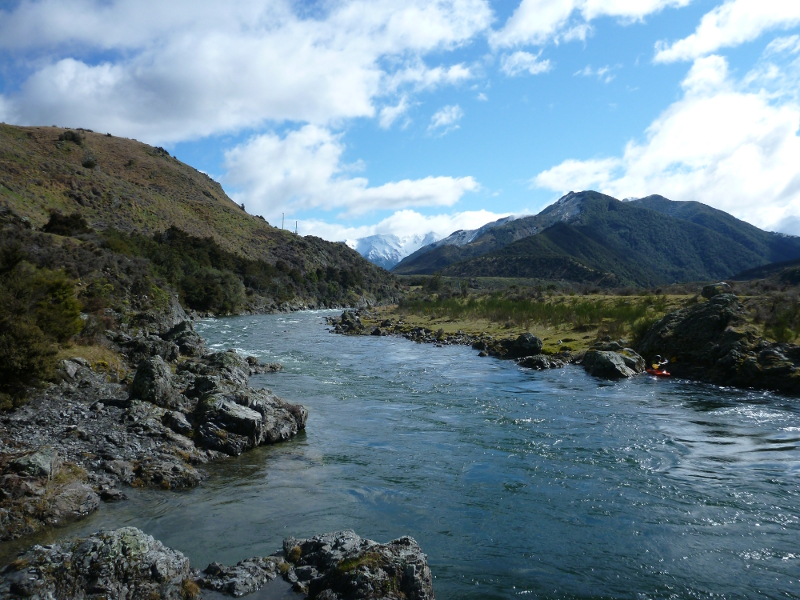
Looking upstream towards the mountains
We drove up to the Hurunui, did some shuttling for a group that just planned to run the gully and then drove up to Jollie Brook with one of their group, so he could drive our vehicle back to the Seawards takeout. On arrival at Jollie Brook, we found everyone else had parked by the swing bridge, instead of at the camping area further up, meaning that we’d miss out on the Jollie Brook rapid. Some of the group walked upstream and ran the whole rapid, but I wasn’t feeling up to lugging my boat around and so just did a bit of a warm up below the swing bridge. Not having done any serious paddling for a while left me feeling pretty tired and weak after just a little playing, but it was nice to note that my new spray deck and dry jacket seemed to be doing their job and I didn’t have that cold dribble of water down my back. Eventually the rest of the group made it down from the top of the rapid, Ian got his raft inflated and we were underway. The sun was out and after the warm up, I was feeling pretty hot inside my new jacket and not cold and wet like usual, despite the snow on the surrounding hills.
Matt surfing in a hole
At 65 cumecs, the current was pretty swift and the rapids and wave trains were a lot bouncier, its was really good to be back out on the river. The river was much as I remembered it, with the only major change of note is that the old “Eddy of Doom” is now completely blocked off by a rocky, gravel bar and the river bypasses the bluff completely. As we had a strong group so there where no dramas, even though I was still had the “early season” lack of confidence and was feeling pretty nervous about Devil’s Fang Falls. We hadn’t stopped to check it out on the way up and I wasn’t really sure what it looked like at this flow.
As I was tail end Charlie, I watched the others go over on by one. Matt was first and took an unusual left-hand line and I watched his small play boat perform an unintentional tail stand before disappearing from sight. The rest of the group, mostly in creek boats, disappeared over the horizon line on the more common right-hand line and didn’t seem to have any problems. Finally it was my turn, I drifted down the rapid, checking ahead, skirted the holes at the top of the rapid and then down a clear tongue. None of the usually features were visible, the fang buried under foaming white water. It was messy at the bottom and when I hit the aerated mass, a wave hit me from the left and I was over, a quick failed roll in the boiling water to grab a breath and then a second successful one to paddle out and down the out to the eddy at the bottom. There are few things as confidence building as knowing you can successfully roll when you need to. Now I felt much better about running Maori Gully.
Nicole runs a rapid
Two of our group got out a Seawards and we gained an extra paddler at the magic roundabout. I was playing it safe and generally bombing the rapids, avoiding the other paddlers where possible. I had another successful roll near the bottom of bum rock rapid, when something caught me off balance. The escalator was pretty tame at this flow, mainly washed out but cheese grater was pretty messy. Recently people have been having some exciting experiences on it, as it has been kicking strongly to the left where there is a hazardous under cut. This time I took the chute on the right-hand, paddled hard and punched through the wave at the end, beyond the boiling water tried to spin my kayak while I tried to stay on line and up right. It must have worked and I paddled into the eddy.
Bill surfs one of the big waves above the corner rapid
The river wide waves above the corner rapid were big but presented no dramas and several kayakers stopped to have a bit of a play, while I took a few photos. We also stopped for a play at the pop up spot, which was in fine form, easily flipping even the larger creek boats. Then down to the take out and up the steep track to the top. As I clambered out of my boat, it was nice to note that the inside of my kayak was still dry and I had stayed warm throughout the entire trip, despite the occasional roll, thanks to my new gear. I felt exhausted and my boat seemed to now weigh a ton, but I staggered onwards and upwards until I made it to the car park where our vehicle and dry clothing awaited. We got changed and the shuttle got run and then it was off to Brew Moon for a beverage and a bite to eat before heading back to town.
Date: 21/06/14 River: Ashley River, Canterbury, NZ River Conditions: 14 cumecs at Ashley Gorge. Water clear, swift and cold. Grade 3. Weather Conditions: Sunny & warm with strong NW winds. Number on Trip: 9 people. Time on River: 3.5 hours. Comments: Matt organised a mid-winter trip down the Ashley River to celebrate the Winter Solstice and I was just coming to the end of a course of antibiotics to treat a chest infection that still hadn’t completely cleared up, I was in two minds as to whether to go or not. With the flow being a cruisy 14 cumecs and the temperature predicted to reach 17 degrees (pretty good for mid-winter in Canterbury), I decided I’d kick myself if I didn’t go. As the water would still be cold even if the air temperature was warmish, I packed by wet suit & a few extra warm layers (but forgot to bring my towel).
The 10am meeting time was also a welcome relief, meaning that the sun was well up and the temperature was reasonably pleasant. After short wait for John to arrive from his mid-winter swim at Sumner (something he didn’t repeat on the river), we were off. We met up with Ross at the Domain, got changed and drove up to the put in at the middle bridge. We were all dressed warmly, even Murray had a dry suit on and once we were on the water it almost seemed too warm, though once out of the sun and a bit wet, I certainly appreciated the extra layers.
Colin scouts his line down the rapid.
The flow was pretty low, meaning there were plenty of rocks to dodge but there wasn’t much push so there were some nice opportunities for playing. As I wasn’t feeling 100%, I tended to take fairly easy lines and didn’t spend much time catching eddies on the way down the rapids. Our Chilean visitor, the only one in our group who hadn’t paddled the river before, tended to spend most of his time at the front, bombing the rapids and often disappearing into the distances, until it was explained that this probably wasn’t a good practice.
Nicole runs a rapid.
John H on the same rapid.
No real dramas, Colin took a swim (possibly after getting stuck on a rock, not really sure, but it was in an odd place) and while he self rescued, we spent a bit of time chasing it down the gorge proper, trying to push it into an eddy. Ross also to a brief swim after tipping in an eddy and his roll not quite working, but was soon back in his boat. I had a brief bit of excitement on the last major rapid, coming down the left channel, I ended up running over a series of shallow rocks and finished with an unplanned tail stand before completing the rapid. John noted the moved, decided to avoid that line and then apparently repeated my actions due to the current doing unexpected things to him.
The group carries on down the lower part of the gorge.
After the main drops the paddle out was a little harder than usual, with the low flow making for some fairly flat sections and the effects of the chest infection reducing my overall energy levels (not to mention my lack of recent paddling leading to some sore muscles). Still there were still some nice little rapids, wave trains and even the odd surf spot to make it all worth while. Still I has quite glad when the get out came into view.
It really was a perfect mid-winter’s day.
The scenery was really great with the rock, cliffs and bush cover hills and with the warm weather and sunshine, being there was a real pleasure. It is something really specially to be in these beautiful places, enjoying the river & what nature has to offer with a nice bunch of people. These are the kind of days that make you glad to be alive.
After the shuttle was run, we headed to Cafe 51 in Oxford for a well earned cup of coffee & a muffin before driving back to town as darkness fell early. Home with fish & chips by six o’ clock, feeling tired & sore but glad to have spent an excellent day on the river.
Date: 21/04/14 River: Ashley River, Canterbury, NZ River Conditions: 27 cumecs at Ashley Gorge, possibly incorrect, estimated at 38 cumecs, water discoloured, swift and cool. Grade 2/3. Weather Conditions: Sunny & warm at first with a cold, south-easterly change in the afternoon. Number on Trip: 10 in total, 4 kayakers, 2 catarafts & 1 paddle raft with 4 people. Time on River: 3.5 hours. Comments: Having had a series of almost two weeks of rainy days since arriving back from sunny Queensland, being trapped inside was getting a little tiring, so it was nice when the sun finally came out. Heavy rain on Friday had pushed the Ashley up to almost 500 cumecs and paddling that was not for the faint hearted. Fortunately by Monday the flow had dropped and the sunny weather seemed to be holding and I was able to tag along with Hugh’s “Rubber” trip, a mainly rafting focused trip.
Instead of meeting at the Belfast Tavern as usual, we planned to meet at the picnic area at the Ashley Gorge Domain. It was a very pleasant day for a drive in the country, with the sun shining down and some good tunes on the stereo. Hugh was there preparing his rafts when I arrived, so I got changed while waiting for the others to arrive. Hugh and Doug had their one person catarafts and Ian had a more standard style raft with 3 paddlers. Bruce, Tania, Mark and myself had our kayaks and since they were already inflated, we didn’t take long to get them sorted out. After some discussion, it was decide to paddle the whole gorge from the Lees Valley with Mark possibly getting out at the middle bridge. We ran the shuttle, leaving Mark’s car at the bridge and after some heavy haulage of rafts through the gorse & broom, we were on the river and away.
The group heads off down the river with the kayakers in the lead.
The first half of the trip was pretty cruisy, paddling the fast flowing current with the sun sparkling on the water. Apparently Bruce tipped on one of the early rapids and got a little knocked about by the rocks in the shallow flow before being able to roll upright, some how I missed this. I didn’t play much, being happy to bounce down the wave trains and quite aware as how long the trip would be and not wishing to tire myself out too early. The scenery was beautiful and there were numerous waterfalls along the sides of the river, a result of all the recent rain.
Captain Fox & his gallant crew.
By the time we reached the Middle Bridge, the sky was dark and grey and the temperature had dropped significantly and I was quite cold and wet. Mark got out here and the rest of us continued down the gorge. Tania had a swim on one of the early corners and after she was rescued, Hugh parked his cataraft in a small eddy on the far side of the river. While Bruce was helping Tania back into her boat, Hugh decide to exit his eddy and move further down the river. Unfortunately he didn’t quite make it and next thing I knew, the raft got pushed against a bluff below the eddy, then flipped on it’s side before overturning and dumping Hugh in the water. I alerted the others and attempted to push (without much success) the large raft into an eddy with my little kayak while the others got Hugh to shore. Captain Fox and his crew were soon on the scene and managed to shunt the raft to the side while Doug ferried Hugh across on his cataraft.
Doug & Hugh running a rapid in their catarafts.
We were soon back underway, but at the next major rapid Tania took another swim and as she was getting a bit cold (the water was freezing, especially if you spend a little bit too much time in Queensland, like me) decided to join Ian’s crew while Hugh transported her kayak on the back of his cataraft.
Once in the gorge proper, the rapids came thick and fast but no real dramas. The main drop was not so much a drop at this flow, leading to some speculation as to the accuracy of the flow gauge and we all shot down the chute without a problem.
Captain Fox & his crew…
… attempt a different line.
After the last major rapid, I felt a bit more confidant to have a bit more of a play and really enjoy some the big wave trains and remaining rapids. Did manage to tip over whilst floating backwards down a relatively flat section, trying to get a photo of the group. Fortunately I had the camera secured to my buoyancy aid or it wouldn’t matter how waterproof or shock proof it was, if it was at the bottom of the river. I think I proved Ian’s crew with a bit of a laugh, but didn’t get the photo I wanted. The sky was very dark and rain was threatening as we reached the take out and I was pretty cold by this stage. It was good to get out of my wet gear (my “dry” jacket now keeps me anything but dry) and into some warm clothes and once I was packed up I said goodbye and headed straight home while the others completed the shuttle and Tania cycled home from the Domain.
Date: 22/3/14 River: Hurunui River, North Canterbury, NZ River Conditions: 15.25 Cumecs at Mandamus. Grade 2+(3), water clear. Weather Conditions: Sunny, warm with occasional NE winds. Number on Trip: 8 (5 doing Maori Gully). Time on River: 4 hours. Comments: Having hardly paddled at all this year due to various other commitments and having not paddled the Hurunui River since February last year, it was great when Graeme organised a trip to take advantage of the fine weather (last weekend saw the tail of Cyclone Lusi bringing rain and high winds to Canterbury but not the expected flooding).
After meeting up at the Belfast Tavern, we were soon on our way up to the Jollie Brook put in. Fog shrouded the land from Weka Pass but cleared as we headed down towards the river. We paused to check out Devil’s Fang Falls, which at 15 cumecs was looking particularly bony. After removing a stick from near the bottom, Matt & I decided running it would be OK but everyone else thought the best route probably involved the road.
A very bony Devil’s Fang Falls, the line on the hard river right had a bit of a bite.
At the put in above the Jollie Brook rapid, we got changed and then waited while the shuttle was run. When the vehicle got back, Graeme noticed a hissing sound from one of the rear tyres as the air rapidly leaked out through a large hole with a chunk of rock stuck in it. The team soon gathered round and got the flat tyre swapped out and then it was in to our boats and away, while a group of rafters pumped up their rafts and ran through their pre-trip briefing.
The rafters go by.
The rafters past us at one of the early rapids as we stopped for a play and we followed them down the river towards the Dozy Stream put in. Most of the group got out on the river right above Devil’s Fang Falls, while the rafters portaged their rafts down the left hand bank. I carried on down, feeling a little apprehensive, and Matt eddied out at the top of the rapid. I wove my way through the holes above the main drop. On the water, the line looked pretty narrow with a number of folds and cross currents, however I was committed and down the chute I went. Things went a little pear shaped near the bottom and I ended up tipping and loosing a little skin on my hands as my paddle grazed along the “fang”. I rolled up promptly in the froth at bottom, eddied out and waved back to Matt. Matt came down without any dramas and we had a bit of a play while the others made their way down to the put in and the rafters relaunched their rafts.
Ken shoots a rapid with style.
After a short break and a bite to eat, we carried on down to Seawards without any dramas. The river had changed a bit over the last year and the entrance to what had in the past been the “Eddy of Doom”, was closed off and the river bypasses the previously fearsome bluff.
At Seawards, our group decreased in number and the second leg of the shuttle was run while the five remaining paddlers carried on through Maori Gully. With a low flow Maori Gully was pretty cruisy and we caught up with another group of paddlers that had just spent the day doing gully runs. Cheese grater was also particularly bony, with a number of visible rocks in the drop, the current also kicks left towards an undercut and so we ran it on the right, facing right. Tried out the pop up spot without much luck in the low flow and finally arrived at the take out absolutely exhausted. Got out, staggered up the hill and managed to be the last one out of their wet gear and into dry clothes. Then straight back to town and home, where I’m still feeling pretty sore several days later.
Date: 9/01/14 River: Ashley River, Canterbury, NZ River Conditions: 28 cumecs and falling at Ashley Gorge, water discoloured, swift and cool. Grade 3. Weather Conditions: Cool, occasional cloud with sunny spells. Number on Trip: 4 people. Time on River: 2 hours. Comments: Kerry organised this impromptu trip and originally advertised it on Facebook with a meeting time of 4:30pm, at which point I calculated that getting on the river around 6pm would make for a late get out and an unhappy wife and decided not to go. Fortunately shortly before I sent through my decision, Kerry called to let me know the group would be meeting at the more civilised time of 2:30pm, so I quickly sorted out my gear, loaded the car and headed for the Pegasus Tavern. Kerry arrived with Suzi and then André turned up and we loaded Kerry’s car with gear. We picked up Dave, the camp manager at the Ashley Gorge Domain, as he was to drive the vehicle back for a small fee, thus saving on running a shuttle.
André playing on one of the rapids.
The river was brown and swift but not too pushy. It was quite different from many of my recent low flow trips on the Ashley, with many of the rocks covered or at lest partial obscured by the brown water, making for the odd surprise as you picked your way through the various holes only to end up hitting a rock. Still once I got over my initial nerves (i.e. after the last grade 3 rapid), I felt much more relaxed. It was Suzi’s first time down the Ashley gorge and only her second grade 3 trip and she did really well and managed to pull off a number of combat rolls. We were off the river around 5pm, passed John H & Bruce L heading to the river on the way home and I was home in time to cook dinner at around 7pm and Lauri scarcely noticed I was gone. Kerry did get a few texts/calls from people who hadn’t got the updated trip information and had been waiting at the Pegasus Tavern for some time. So it is worthwhile making sure that you let the trip leader know that you plan to be on a trip so they can let you know if any of the details change.
Date: 24/11/13 River: Waiau River, North Canterbury, New Zealand. River Conditions: 50 cumecs at Marble Point. Water discoloured, cool & swift. Grade 2. Weather Conditions: Sunny & warm, light NW winds. Number on Trip: 22 people. Time on River: 5 Hours. Comments: This was an unexpected bonus of a trip as I hadn’t thought that I’d be able to fit in any kayaking between getting back from the Sunshine Coast, going to Auckland for a Movie Marathon and then flying back to Australia. There were lots of new faces and plenty of beginners, but the day was warm and so we took our time getting down the river. A number of people decided to swim after failed rolls and so there was the odd rescue but no dramas. Hugh was out in his kayak for the first time in over a year, leaving the cataraft at home this time. The river was running fairly swiftly and so there were plenty of spots for a little play, which meant I was pretty tired by the end of the trip. Nice to be out on the river again after a long time stuck in Australia. Thanks Graeme for organising a superb trip on such a glorious day.
Getting ready at the put in
Playing at one of the larger rapids on the river
Playing at one of the larger rapids on the river
Hugh shows the line at Shark’s Tooth rapid
Running Shark’s Tooth rapid
The now wonky bridge at the get out
Date: 27/10/13 River: Hurunui River, North Canterbury, New Zealand. River Conditions: 370 cumecs at Mandamus. Water discoloured, cold and swift. Grade 3 to 4. Weather Conditions: Cold and rainy, strong nor-westerly winds . Number on Trip: 2 people. Time on River: 0 Comments: Lauri was keen to go camping up at Lake Taylor, however gale force nor-westerly winds and heavy rain about the main divide put a bit of a dampener on that. She was still keen to have a bit of a paddle and Sunday looked liked the weather would have subsided somewhat by then, so on a beautiful sunny day we loaded up the car and headed out of town. Over the Waimakariri River, looking very brown and swirly and running at over 1000 cumecs, and then over the Ashley River, running at almost 100 cumecs. Past perfect picturesque rural scenes with bright green grass and beautiful clean animals, that reminded Lauri of the too good to be real, picture postcards from childhood. Tasty toasted bagels for lunch at the Rocking Frog in Waikari and a look at the Weka Pass steam train and then off into the hills.
The view looking up Maori Gully
Looking down the Seaward River towards the entrance to Maori Gully
Dozy Stream put in
Where Devil’s Fang Falls should be
Looking down into the gully above the South Branch confluence
As we crossed the Waitohi River (which was flowing at a good rate and may have provided a fun paddle provided the weren’t any willows blocking the river), the weather deteriorated. By the time we reached the Maori Gully take out, a cold rain was falling and this grew heavier as we moved up the valley. The river was pumping (having dropped from 419 cumecs earlier in the day) and a lot of familiar features were washed out, though many of the bluffs looked quite ferocious. The was a was out in the road just after the South Branch bridge and a temporary repair had been made, but when we got to the next ford, we turned back rather than attempt a crossing in our low slung, city car. We never reached Lake Taylor and neither of us felt like spending a lot of time out of the car, especially with the freezing cold, driving rain that was now falling, so it was back to the Rocking Frog, sunshine and a good cup of hot coffee.
Date: 22/9/13 River: Ashley River, Canterbury, NZ River Conditions: 14 cumecs at Ashley Gorge, water clear, swift and cold. Grade 3. Weather Conditions: Cold, low cloud with intermittent rain. Number on Trip: 10 people. Time on River: 3.5 hours. Comments: This was a nice, low volume Ashley River trip down the grade 3 section of the Ashley Gorge. The weather wasn’t too flash and the idea of being wet and cold wasn’t all that promising. Still the opportunity to have a cruisy trip down the lower gorge and hopefully get some photos was appealing so Sunday morning found us standing around the Belfast Tavern car park in a light rain. Vehicles were loading and it was off to the Ashley Gorge Domain, where we were thankfully able to change in the shelter of the modern, public toilets instead of the old, dark changing room, with its wet floor. Back in the vehicle and up to the put in, with a slight halt to reattach Kerry’s roof rack after it failed under load, spilling boats on to the road side.
Alex breaks into the eddy at the bottom of one of the early rapids
On the water, things felt better, the rain and cold largely forgotten, though I still had some early season nerves. We had a good strong team and Kerry encouraged people to try new things and try and catch as many eddies as possible, and much fun was had with little or no drama. The rain made the rocks shine and highlighted their beauty, contrasted against the greens of the bush and moss and the flowing water. The low cloud, gave the scene a magical, misty feel and it was a real pleasure to be on the water.
You never know what flotsam & jetsam will wash up in the forever eddy before the main gorge
At the main drop, we stopped so that people could run it multiple times and I was able to get some photos from the shore (usually I never get out of my boat, so pictures are restricted to the view from the cockpit). Kerry showed his skills by surfing his playboat above the drop before doing cart wheel over the edge. All I managed was to tip at the bottom of my first run, but managed to do a roll on my first go, which improved my confidence. I tipped further down the river on one of the random grade 2 rapids further downstream, striking my helmet against a rock in the shallow water, no damage to me or my helmet and I was soon upright, with another solid roll. Kerry was amused, being one of the few people to notice as I was at the back of the group.
Kerry showing his skills on the main drop
Really enjoyed the trip, the natural beauty was truly stunning and at this flow made the rapids fun and exciting, without the more daunting debris and swirling brown water that tends to be present at higher flows. Kerry paddle in a short sleeved top but by the end of the trip, I was pretty cold even with my poogees, half gloves, hot head, long sleeved, dry top, fuzzy rubber top and 2 layers of poly pro, Queensland has made me soft. It was nice to get changed in the dry again and even better to be enjoying a long black and chocolate brownie in Seagers Café in Oxford, whilst still being home in time to cook dinner before going out for the evening. Thanks Matt and everyone who came along for a great trip.
Date: 24/8/13 River: Ashley River, Canterbury, NZ River Conditions: 14 cumecs at Ashley Gorge, water clear, swift and cold. Grade 2. Weather Conditions: Sunny and clear, cool. Number on Trip: 7 people. Time on River: 2 hours. Comments: Colin R put out the call for anyone interested in a pre-season refresher trip and with a number of us keen for a nice easy trip down the upper part of the Ashley River with the added benefit of being able to get home early, a plan was soon put in place.
We put in at the Lees valley and had a fairly relaxed paddled down the first part and through the early rapids. The river flow was low but there was still plenty of water and only an occasional shallow spot. At one of the more difficult rapids, a bit of a long, grade 2 boulder garden, Graeme eddied out with the group to the river right above the large boulder at the start of the rapid, while I carried on down the more interesting left-hand channel and eddied out midway down the rapid. The first paddler down had no problems and carried on downstream. He was followed by Colin, who eddied out opposite me. As I looked down the river, I noticed the first paddlers boat was upside-down with him floating along with it. I alerted the others and raced down stream to help him ashore and pick up the resulting garage sale. Everyone else made it down without any additional drama and we were soon under way again.
A few more rapids followed without drama followed by a shore break for some food and a stretch of the legs. The water was clear and it was a real pleasure to be out on the river, especially when the sun managed to make it’s way into the gorge.
Colin R leads the way
Hermione & Robin show what you can do with twice the boat & half the paddles
I was starting to feel a little tired as we neared the middle bridge and the end of the trip, a result of the lack of pre-season Brass Monkey training and catching plenty of eddies and waves on the way down. Colin decided to do a practice roll just below the bridge, which resulted in a swim. Fortunately everyone managed to get him and his gear to shore before it could be carried into the lower gorge.
It was a lovely day out and it was a pleasure to be out on the river with such a great group of people, with a special thanks to Colin for organising the trip and getting the season off to a good start.
Date: 12/5/13 River: Ashley River, Canterbury, NZ River Conditions: 13 cumecs at Ashley Gorge, water clear, swift and cold. Grade 3. Weather Conditions: Sunny and clear, cool. Number on Trip: 6 people. Time on River: 3.5 hours. Comments: Earlier in the week I’d watched the gauge on the Ashley River rise as a cold, wet south-westerly front rolled through and much as I like paddling the Ashley, I was having a hard time getting enthusiastic about spending too much time in the freezing rain. On my last break, I’d passed on a similar opportunity to paddle the Ashley after the proposed Rangitata trip was diverted due to another cold front bringing a heavy downpour. I guess that too much time in Queensland has made me a bit soft.
Things were looking up when the sun came out on Saturday but the Ashley was continuing to fall, when John H suggested either doing a run down the Ashley or the Hurunui on Sunday. I sorted out some gear in the evening but didn’t fully commit myself to the trip as with plans for Sunday evening I would be able to make a trip to the Hurunui. I woke early on Sunday morning and the day looked perfect and the Ashley was still running at 13 cumecs so there would be just enough water but I texted John just to be sure. Everything was looking good for a fun day on the Ashley.
The Belfast Tavern car park was relatively crowded but not a kayak in sight. The over 60’s tramping club had chosen this as their meeting place for a day trip. I spotted Hugh with his cataraft, all ready to go, mounted on one of the smaller trailers you could possibly get. Bob, Kerry and John H soon turned up and we headed off to meet Carston at the Ashley Gorge Domain.
The water was very cold, running swift and clear, but when the sun made it down to the bottom of the gorge it almost like summer. It isn’t often you can paddle the Ashley with weather like this, usually it is cold and rainy and the river brown and turbulent. We made our way down the river and at one rapid Kerry suggested playing a game to see who could catch the most eddies, with the winner scoring at least in the high twenties. Later at the forever eddy before main set of rapid, John found a tennis ball and a game of eddy polo ensued. This resulted in some amusement as paddlers attempted to recover the ball from whichever tricky eddy it had been thrown into. Eventually the ball split in half and sunk out of sight.
When the sun made it into the gorge, it almost looked warm
The main rapids were fairly cruisy given the lower flow, but still fun with plenty of rocks to dodge and eddy’s to catch. John decided he was interested in trying out Kerry’s Bliss Stick Super Rad (a very short play boat) and so after managing to finally squeeze his legs in, he had a short but exciting run down the next rapid before swapping back to his more forgiving creek boat.
John H squeezes into Kerry’s playboat
Shortly after returning to his own boat, John took a swim on one of the later rapids, after his paddle disappeared from his hands at the top of the rapid (naughty rock!). After staying up right briefly, he was over and out of his boat and then the garage sale was on. Kerry managed to push his boat to shore, while John self rescued. Unfortunately there was no sign of his paddle so I followed him up stream with my boat to help him look for it. After some extra swimming about, a call went up from down stream as the paddle had turned at the bottom of the rapid and John got an extra swim to get back to the other side again. I paddled down the rapid again with a roll at the bottom due to a slightly messy manoeuvre, soon upright again but the water sure was cold though!
Hugh negotiates the final major rapid in his cataraft
A few more rapids but no more drama. It was good to pass the water level monitoring point as it indicated we were almost out and I was pretty cold by this stage. We got out and changed into our dry clothes and then stood around, enjoying the sunshine, while the shuttle got run. A quick drive back to town and then home in a timely fashion so as not to incur the wrath of Lauri for being late.
Date: 7/4/13 Location: Lyttelton Harbour, Banks Peninsula, Canterbury, New Zealand. Weather Conditions: Overcast and cool. Number on Trip: 8 people. Time on Water: 4.5 Hours. Comments: I was back home again and the scheduled WWCC trip for the weekend was listed as a sea kayaking trip organised by Peter D. I asked Lauri if she was interested and as she was, I put our names down to hire a double kayak for the trip. The basic plan was to paddle from Cass Bay to Ripapa Island and then back to Quail Island for lunch and an explore before returning to Cass Bay. As the day drew closer we were a little worried by the distances involved and the possibility of bad weather, though Sunday dawned cool and overcast, the rain held back and Lyttelton Harbour was smooth and still without the hint of a wind to stir its’ surface. Once on the water, our group was soon under way with many of the paddlers powering ahead. The rudder of our kayak got stuck and wouldn’t lower into the water and we had to get another kayaker to fix it on the water. After this I realised I didn’t know how to adjust the foot pedals and with the spray deck on and most of our group disappearing into the distance, I decided just to stretch my legs out and wait until we stopped to fix it.
Heading for Ripapa Island. Photo by Lauri
It was a fair way to Ripapa Island and it was hard to keep up with the group, but we soldiered on, with Lauri putting in a very good effort especially considering how little she has paddled recently, I felt hard pressed to keep up with her. We went ashore at Ripapa Island after landing on its’ rock shore and scaling its’ ramparts using a driftwood tree that had been leaned against the wall. Once inside, we explored the buildings, tunnels and gun emplacements, all of which seemed little damaged by the many quakes that had struck the region. The island has had an interesting history, from its’ occupation by Maori, its’ fortification against the 19th century Russian menace, the imprisonment of World War 1 German raider Felix Von Lucknow to today as a slightly earthquake damaged tourist attraction. Technically it is closed to the public at the moment but as we didn’t come through the front gate, we didn’t see any signs that may have been there.
Me posing by one of the guns on Ripapa Island. Photo by Lauri
From Ripapa Island we paddled back to Quail Island at a slightly more leisurely pace. Landing in a sandy bay was easy, though pulling the 5.5m long, 40+kg sea kayak up to above the high tide mark was a little demanding. We ate lunch in the picnic area and then set out to walk around the island and visit the old leper colony and information centre. Some nice views, especially looking down at the ships graveyard and trying to make out the various wrecks.
Exploring “inside” the barque “Darra”. Photo by Lauri
Back to the kayaks and off around the island. We explored the ships graveyard up close, paddling between the ribs of the barque “Darra” (built in 1885 and laid to rest here in 1951), before heading for home. We all had an enjoyable day out but it was nice to get back to shore before the rain started. Thanks Peter for organising the trip and well done Lauri for paddling so far (around 15km I guess).
Date: 16/3/13 Location: Lake Cootharaba, Sunshine Coast, Queensland, Australia. Weather Conditions: Sunny and warm. Number on Trip: 1 person. Time on Water: 3 Hours. Comments: This was meant to be my rest day before leaving Cooroy and heading back to Blackwater but the Sunshine Coast is too beautiful not to explore. Due to a series of events, I ended up climbing Mount Ninderry (309m) and enjoying the peace and solitude at the top, while gazing down on the surrounding lands. Next stop was Mount Tinbeerwah (265m) with beautiful views over the Noosa Region, Mount Cooroy, the Noosa River and lakes, a nice easy walk with the car park almost at the top. From here I had lunch in Noosaville before heading to Boreen and then Elanda Point on the shores of Lake Cootharaba.
Malucca trees on the shore of Lake Cootharaba
The launch site was a sandy beach, surrounded with tall, papery barked Malucca trees, growing out of a tea coloured wet land. The lake is apparently the largest in Queensland and I planned to paddle as far North as I could towards the upper Noosa River and the Noosa “Everglades”. The sign at the put in said the trip to Fig Tree Point would take about 1.5 hours, but I guess that was for someone paddling a 5m long sea kayak not a 2.2m white water play boat. Half an hour later I was at Mill Point, watching two large sea eagles as they flew from tree to tree to avoid the strange man in his little red and black kayak. The end of the lake still distant but I decided to keep going as there was still around 2.5 hours before sunset. The day was beautiful and clear, the lake’s surface was a little choppy as I paddled into the wind, the water was tea coloured and in places even reddish where the light shone on the sand in the shallows, in the distance the giant sand hills of the Great Sandy National Park towered over the forest covered shores I was heading for.
Looking across Lake Cootharaba to where I planned to paddle to in the far distance
As I neared to the far end, a couple of boats appeared and I guessed that was the point I was to make for so I kept going, I wasn’t exactly sure up until then. At Kinaba, there was a information centre built on piles over the lake with a landing so I got out to stretch my legs and get my bearings. Once on the water again, I was able follow the signs up Kin Kin Creek, past Fig Tree Point, across the Fig Tree Lake, covered with lily pads and beautiful purple blooms and then up the upper Noosa River. The river flows through a low, forested wet land called by the tourist brochures the “Noosa Everglades” and described on a number of sites as one of Australia’s most beautiful rivers. Its mirrored surface and lushly vegetated banks were certainly quite beautiful and definitely worth the approximately 8-9km paddle to get there.
A yacht motored past me from upstream and I briefly pondered asking for a lift back, before watching them disappear down the river. After a short distance up the river I decided to head for home, this time paddling around the far side of the island, this turned out to be a fair distance and once I cleared the top of the island, my starting point was a distant blur on the horizon. It was pretty gruelling paddling straight across the lake, the surface was choppy at an angle to my boat, with it’s nose burying at times and surfing along at others. Occasionally reasonable sized fish would leap from the lake, landing with a splash, presumably fleeing some larger, unseen fish beneath the surface. Since the fish weren’t particularly small, it did have me wondering exactly what there might have been fleeing, apparently bull sharks can swim up the river so that was a possibility but I didn’t see any sign of that.
Eventually I made it back to Mill Point and was on the home stretch, the swell lessened as I watched the sun disappear behind the trees and it was almost twilight by the time I was back at the put in. The mosquitoes swarmed around me as I carried my kayak back to the car, at times covering my exposed arms. I only had a short sleeved top and shorts on, so it was a relief to put my long sleeved paddle jacket on while I got changed and packed up my gear. I stopped off for another take away curry and a beer before heading home to do the washing and pack my bags for the trip to Blackwater the next day.
Date: 10/3/13 Location: Lake MacDonald, Cooroy, Queensland, Australia. Weather Conditions: Windy and occasional drizzle. Number on Trip: 1 person. Time on Water: 1.5 Hours. Comments: I’d picked up my Australian based Blitz from where it had been languishing under Nick’s house in Brisbane for nearly two years, and transported up to the company house in Cooroy on the Sunshine Coast. This was the first time I’d seen it since leaving the Hunter Valley and it was good to have the opportunity to use it again. Before setting out, I checked the kayak for any creepy crawlies that may have taken up residence in it during its long hibernation, last thing you want to discover is a snake or spider after you’ve popped your deck on. Fortunately there were none and I was soon on the water.
Lake MacDonald viewed from the top of Mt Tinbeerwah
It was quite a relief to be off the computer and to get out of the house. The was a wind blowing down the lake, making the surface a little choppy and it was fun to power along with the spray breaking across the nose of play boat, while not exactly suited to flat water paddling, it is definitely better than the alternative of not kayaking. I paddled as far as I could down one of the arms of the lake, it was quite beautiful, surrounded by forest, the surface of the lake dotted with lily pads. The paddle back into the sunset was a bit strenuous and it was almost dark by the time I reached the boat ramp, but whenever I needed a rest, I just stopped paddling and enjoyed the gentle wash of the lakes surface, the call of the water birds, the light rain drizzling down and the beauty of the fading light reflected in the water. Then it was back to the house for a shower and a tasty vindaloo from the local Indian Restaurant.
Date: 25/2/13 River: Pororari River, Punakaiki, Westland, New Zealand. River Conditions: Low flow. Water crystal clear, cool and still. Grade 1. Weather Conditions: Sunny. Number on Trip: 2 people. Time on River: 1.5 Hours. Comments: On our final day, while we waited for the dew on our tent to dry off, we decided to have a short paddle downstream to explore the estuary at the end of the river. We paddle out the where the water flowed in to the sea and then explored along the massive cliffs at the far end of the bay and admired enviously, the superbly located houses overlooking the estuary. We then paddled up stream as far as we could go without leaving our boats before returning to the camp ground for a final shower and a pancake, second breakfast in a cafe in Punakaiki before packing up and heading for home. The pancakes were good, but no where near as good as the buttermilk blueberry pancakes that Lauri cooked on the BBQ for breakfast on the previous days.
Date: 23/2/13 River: Pororari River, Punakaiki, Westland, New Zealand. River Conditions: Low flow. Water crystal clear, cool and still. Grade 1. Weather Conditions: Slightly overcast/misty but sunny. Number on Trip: 2 people. Time on River: 3 Hours. Comments: When we decided to have a camping holiday in Punakaiki, near the famous Pancake Rocks, we thought it would be nice to take our kayaks along to paddle the Pororari River near the camp site. As we sorted out the required gear for the holiday, the tent, the new BBQ, chairs, table, bedding etc, I noticed we had a lot of gear to pack and only a smallish car. I briefly flirted with the idea of just hiring kayaks at the river but the cost was relatively high and after some discussion we decided against it. Fortunately everything fitted in and the day after our arrival in Punakaiki, found us sorting out gear for our trip up the river, “it isn’t an expedition” said Lauri, as I fluffed about putting in throw ropes, rescue gear, torches etc in to my boat (“Be Prepared”, is my motto too). So a short walk later and we were on the river. Lauri hadn’t paddled since her last canoe polo game at QEII before the earthquake wrecked that facility, but after a short reorientation, was happily racing off upstream.
Lauri on the Pororari River near Punakaiki
The scenery was superb, great towering cliffs of limestone clad in lush green rain forest, nikau palms and pungas pushed up through the bush, giving an almost tropical look. The water was crystal clear, with a greenish hue and was almost still. Sculptured rocks rutted from the water, making for a very beautiful and photogenic landscape.
More beautiful scenery
We paddled upstream, chatting to the occasional other paddlers we met in their rented Minnows (we were very glad we brought our own), enjoying the scenery and taking lots of photos. Lauri ended up with an excellent collection of some quite stunning photos, while I just had my normal collection of random snaps. As we moved further upstream, the current grew slightly and there were occasional small rapids or riffles which needed to be portaged, or for me to get out of my boat and tow Lauri up them. Eventually we came to a shallow section that would have required a slightly longer walk and as we were both rather hungry, having only muesli bars and oranges, we decided to head back to Punakaiki for a well deserved shower, pie and beer battered chips.
Date: 17/2/13 River: Boyle River, North Canterbury, New Zealand. River Conditions: 45 cumecs at Marble Point on Waiau. 0.608m at Hope Glynn Wye. Water clear, cool and swift. Grade 2. Weather Conditions: Sunny. Number on Trip: 10 people. Time on River: 1.5 Hours. Comments: After some discussion we decided that rather than run some variation on the Hope/Waiau River, which was deemed a little flat and unexciting after the Boyle, we would run the Boyle again. With two paddlers sitting out the second run, the shuttle was relatively easy and we were soon back on the water again. This was a much faster run with no scouting and play was generally restricted to the larger rapids and features. Highlights included Claudia successfully breaking out of a particular eddy that had caused the odd problem on the previous run, and making her way across the face of the bluff to the other side of the river. I took a roll (well the second one worked) after getting pushed against a bluff whilst playing, fortunately no swim on this trip! This time both Tiaan and Stefan jumped from the bluff near the swing bridge while we all looked on.
Time to cool off
Time to cool off
Time to cool off
Everyone was pleased with the trip and seemed to enjoy themselves. We stopped for a drink and nibbles at the Hurunui Pub and consumed a mountain of potato products before heading back to Christchurch through a grey murk that descended around Culverden.
Date: 17/2/13 River: Boyle River, North Canterbury, New Zealand. River Conditions: 45 cumecs at Marble Point on Waiau. 0.608m at Hope Glynn Wye. Water clear, cool and swift. Grade 2. Weather Conditions: Overcast, clearing later in the trip. Number on Trip: 12 people. Time on River: 2.5 Hours. Comments: After finding breakfast, fueling up and paying for accommodation we manage to be away from Reefton by 9am. The morning was bright and sunny and the mountain scenery was spectacular, just like something out of Lord of the Rings. I was a little worried that there may not have been enough water to run the Boyle and we might end up doing the less exciting Hope – Waiau run. We pulled into the rest area near the put in, walked across the road, over the barb wire fence, long grass, thistles and swampy patches to the river. There looked to be enough water to get down the river even though some of the early, wide stretches looked like they might be a little bony. Back to the cars and a short drive back the way we had come, to a parking spot with easy access to the river that I hadn’t noticed as I drove past. In to our paddling gear (more thermals required than for the Arnold the previous day, a quick shuttle and we were under way. The first short section was a little bony but as the river narrowed, we had more than enough for an excellent trip, though many spots would have been a little hard on the helmet of anyone tipping over and trying to roll.
The hard rapids and gorges were scouted so that the beginners could find the best lines, swims were rare and many people were keen to try things out and push their boundaries, which was good. The water was crystal clear and you could see the pebbled river bed slide beneath your boat even in the deeper sections. The gorges were superb, with interesting rapids, beautiful water sculpted rock walls and deep, clear water that sparkled when the suns rays made it through the clouds, the Boyle is quite a magical run and it was a real pleasure to be on the river.
Playing on various rapids on the Boyle
Playing on various rapids on the Boyle
As we leaving the third and final gorge, I did a quick head count and came up with only 11 paddlers, including myself. I recounted again to check but there were still only 11, then I remember noting some one (it turned out to be Tiaan) pulled up of to the side near the swing bridge, soon a figure dressed in kayaking gear appeared at the top of a tall (about 7-8m high) rock next to the bridge. While I watched, they leapt into the river with a mighty splash and bobbed to the surface, an exciting and cooling way to end a successful trip.
Date: 16/2/13 River: Arnold River, West Coast, NZ River Conditions: 40 cumecs at Moana, water clear. Grade 2, water clear. Weather Conditions: Partly cloudy but warm. Number on Trip: 12 Time on River: 3.5 hours. Comments: Approximately 10 minutes before leaving the house, I had suddenly become the trip leader. Fortunately due to Graeme’s (who was feeling very unwell) excellent organisation, I didn’t actually have to do much other than ensure we managed to find the river. After the odd break for coffee and supplies, we found ourselves at the Power Station on the Arnold.
We put in below the bridge and while the scenery was good, there probably wasn’t enough water in the section above the power station outflow to make it worthwhile. There were a number of bony rapids and only two of us managed to staying our boats as we hand walked, pushed off rocks and bounced our way down.
There’s not much water but I’m not getting out of my boat
Boulders abounded but there still was scope for play moves too
Once we reached to power station out flow, the river was more pleasant to paddle and we spend some time here, practicing breaking out, ferry gliding and other skills. From here we made our way down stream, trying to maximise playing and learning experiences.
Playing on one of the smaller rapids
Most of the rapids were fairly small but there were plenty of boulders to practice eddy hopping on and towards the end there were some more challenging grade 2 rapids. This is a beautiful river with some great scenery and is a good learning environment for beginners, it is also under threat from being dammed and just below where we take out is the out flow from the Kokiri meat works oxidation ponds (100% pure, yeah right), kind of sad really. I was pretty tired by the end of the run and there wasn’t too much enthusiasm for a second run so the shuttle was run and we all packed up and headed for Reefton.
Date: 9/02/13 River: Hurunui River, North Canterbury, New Zealand. River Conditions: 22.59 cumecs at Mandamus. Water clear, cool and swift. Grade 2 (3). Weather Conditions: Sunny and warm. Light nor-westerly winds . Number on Trip: 11 people. Time on River: 4 hours Comments: With heavy rains in Queensland postponing my return to Queensland I was able to fit in an additional kayaking trip in. This was planned to be and overnight trip, camping up at Jollie Brook but I was a little less than enthusiastic about camping out and especially about putting on wet gear in the more. So after a lot of humming and harring and general procrastination, I decided just to paddle on Saturday and given how sore I felt on Sunday, this was probably the right decision.
Crossing Sisters Stream to get to the put in above the Top Gorge
I drove up with Dan to the Sisters Stream walkway car park, got changed and then ran the shuttle down to Seawards. It was a hot day and evening without putting on my gear, the walk in to the river was hot and tiring and I was feeling particularly unfit but the river looked cool and clear and very refreshing when we got there. We put in at the swing bridge above the top gorge. There was a short stretch before we entered the gorge.
Looking back up the Valley towards Harpers Pass
The Top Gorge
The Top Gorge
From the gorge, we cruised down through Jollie Brook, past South Branch but as we approached Devil’s Fang Falls above the Dozy Stream put in there was a little apprehension and when everyone pulled over to the side and got out above the rapid, I thought they planned just to have a look at it before running it, however we soon noticed that everyone was carrying their boats, a sure sign of a portage. That left just two of us at the top, prepared to run it. At 22 cumecs the rapid would be a little bony but we had both run it at less and were happy to do it. We both made for the eddy above the rapid and I let the other guy run it first (probe), he went down clean, arriving upright at the bottom. Then it was my turn, I avoided the holes above the drop and slid down the tongue, avoiding the “fang” at the bottom, but with a little too much lean and tipped over, rolled up on my second go and then had a play in the boiling mass at the base of the drop.
We carried on down to Seawards without drama and then sorted out vehicles as some of the group weren’t feeling up to running the gully. I took a bit longer getting the shuttle driver for my car sorted out and had to rush to catch up with the others. The Magic Round-About was in good form, though didn’t seem quite the same as usual and some of my moves didn’t quite work, with the result that my kayak ended up being pushed nose first in to the second rock in the middle of the round-about. I soon ended up the wrong way up and after two failed roll attempts found myself pushed up against the bluff. Another fail roll and I bailed, I flushed out clutching my paddle while my boat continued going round the round-about. Politely declining offers of tows, I swam to shore while Bill rescued my boat and clipped it to his tow line. The towed the water filled kayak to the side where I was waiting, unfortunately it snagged on some rocks and he found himself upside-down attached to a taut town line. He released the tow line and disappeared around the corner where he also bailed out and swam. Hardly an impressive spectacle for the newer paddlers and gully virgins as two of the more experienced kayaker swam before even properly entering Maori Gully.
The rest of the trip went smoothly, with little or no dramas, though I certainly played it safe on the remaining rapids (as my left arm was pretty sore after slipping on the rocks while emptying my boat out). We briefly paused to demonstrate the pop up to Dan, who was paddling the gully for the first time, before getting to the take out and completing the wearying trudge, exhausted, up to the cars and then off home while the others headed back to Jollie Brook to camp.
Date: 6/01/13 River: Clarence River, North Canterbury, NZ River Conditions: 16 cumecs (NIWA), water cold, slightly discoloured and swift. Grade 2. Weather Conditions: Sunny and warm. Gusty nor-westerly winds . Number on Trip: 8 people. Time on River: 3.5 hours Comments: With heavy rains around the main divide pushing river volumes up earlier in the week (the Rakaia topped 5000 cumecs and the Rangitata topped 2000 cumecs, with most other rivers hitting high, though not quite so impressive volumes), Graeme had a hard time figuring out a suitable river for a beginner friendly trip. It was decide that the section of the Clarence behind Hanmer would have enough water to provide an interesting trip. Unfortunately Graeme fell ill and was unable to run the trip so I took over.
None of us had paddled the run before so weren’t exactly sure what to expect. The drive from Hanmer over Jacks Pass wasn’t too bad, a little steep and winding with a gravel surface but in good condition, and we were soon at the put in near the Jollies Pass turn off. While we ran the shuttle, we had a good look at the river as the road ran along side it the whole way. The run looked good from the road, with plenty of small rapids to keep us entertained. We left the vehicles near the bridge above the Acheron confluence and headed back to the put it.
Starting off down the Clarence River
We were soon under way and were rewarded with a very fun day out. Whilst no overly challenging, there was plenty to keep us busy and to challenge but not threaten the newer paddlers with us. There were numerous small rapids, plenty of boulders to practice eddy hopping on, small holes to play in and some nice gorges too. Items of interest were regularly spaced without long stretches of flat water to paddle in between. The weather was perfect and everyone enjoyed themselves and I was certainly worn out by the end of the trip, having not paddled for a wee while.
Running a man-made weir on the Clarence
Running a man-made weir on the Clarence
Busting some moves on the Clarence
While the shuttle was being run, we took the opportunity to explore the nearby Acheron Accommodation House, an old cob (mud and straw mixed together) house built in 1863 and maintained by the Historic Places Trust and the Department of Conservation. The house is open to the public and definitely worth a look if you are up this way.
Date: 11/11/12 River: Rangitata River, South Canterbury, NZ River Conditions: 104 cumecs at Klondyke, water cold, slightly discoloured and swift. Grade 2+. Weather Conditions: Overcast and cool, followed by heavy rain, hail and lightning. Number on Trip: 7 on grade 2 section, 7 on the grade 4 section. Time on River: 3.25 hours Comments: It was decided that the Orari River flow was too low and so the trip was to the lower Rangitata combined with another group doing the grade 4 gorge section. I had been such a long time since I’d paddled the section (and even longer for Matt), I had to look up the details from an earlier trip in 2006 to find out where the take out was. 100 cumecs was a good flow, with plenty of holes of various sizes forming behind boulders, eddies to catch and some nice wave trains. Our group had a good range of skills and it was good to have Stu along (after he decided not to run the gorge), as he was able to provide some coaching to the newer paddlers, as well as the odd rescue.
The group makes its way down a nice rapid.
No real dramas, just a few swims with the kayaker hanging on to their gear for an easy tow to the shore. This section is quite nice for beginners as there are nice flat stretches below each rapids for the recovery of swimmers. The other newer paddler managed to keep herself out of trouble with some nice rolls.
Where’s the paddler gone?
The river was pretty cold and I paddled reasonably hard and was pretty cold and tired by the time we reached the take out at the Rat House (what the building I thought was the OPC is apparently called). Our vehicles and dry gear were waiting, courtesy of the other group. As we got changed the sky darkened and by the time we were fastening down the last boat to Matt’s car, the skies opened up and it bucketed down. Lightning and hail accompanied us to the Peel Forest Store, where we hid from the rain, enjoying some hot food and cold drinks, before heading back to town.
Date: 7/10/12 River: Waiau River, North Canterbury, New Zealand. River Conditions: 94 to 84 cumecs (falling) at Marble Point. Water discoloured, cold & swift. Grade 2. Weather Conditions: Sunny, NE light winds. Number on Trip: 5 people. Time on River: 4.5 Hours. Comments: Earlier in the week an email was sent round saying that some interest had been expressed about a grade 2 trip down the lower Waiau to coincide with the club’s grade 3 to 4 overnight trip down the upper Waiau, all the trip needed was a leader to organise it. I tentatively volunteered as the alternative was no trip and no kayaking for that weekend. The trip was arranged but the river levels were looking a bit high on Saturday with the flow peaking at almost 250 cumecs, a trifle high for a grade 2 focused trip. Fortunately the flow seemed to be dropping and with fine weather forecast for Sunday, it was all systems go. By Sunday morning the flow had dropped to 98 cumecs so it was off to the Belfast Tavern to see who would turn up. I didn’t recognise anyone but we had a reasonable range of skill levels so after some basic introductions, boats were loaded up and it was off to the take out point.
At the take out point, the river looked swift and brown but manageable. We picked a suitable get out point to avoid any drama around the irrigation intake, got changed while Rory loaded our boats on to his vehicle for the drive up to the put in (it was nice to have a big set of roof racks and only 5 paddlers to make the shuttle nice and easy). Leaving James’s car with the dry gear at the take out, we drove up to the picnic area on the Hanmer River. There was sufficient water in the Hanmer River to allow us to float down to the Waiau and avoid carrying our boats too far.
The Waiau was flowing fairly swiftly and was quite boily in places, especially around the bluffs. We managed to get past the first bluff (an old nemesis from my beginner days) and under the Hanmer bridge but shortly after Madi tipped up on a particularly boily corner and was out of her boat. She held on to her gear and James soon had her in tow and back to the shore. Once back in her boat, she paired up with James (a CPIT Outdoor Education student) so he could provide on the river coaching, which worked out great with no further swims.
The larger rapid on the way down to Marble Point was partially washed out and had a nice chicken route down the right hand side but was still fairly exciting. Matt, James and I had a bit of fun ferry gliding across the rapid but it was a bit swift to get any surfing in. A jet boat roared past when we were out of the way and didn’t even look in our direction, though on their way back up the river, one of the passengers did manage to return a wave.
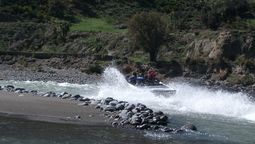
Jet boat heads back up stream through rapids.
Matt rounds Marble Point.
We stopped at Marble Point for some lunch and some slightly water logged and a trifle slimy, gummy snakes thanks to Matt, then back on the river again. It was nice to be out on the river on such a sunny day and the raised flow kept us moving along nicely even through the flat sections. The flow also created some new features while washing out others. Shark’s Tooth approached and the group scouted the rapid and watched while I ran it. No dramas here and everyone got through safely and in an upright position. Madi tipped when we rejoined the main flow but stayed in her boat for a T rescue, which was very well done.
Madi & James on a wave train.
Matt runs the Shark’s Tooth rapid.
The rest of the paddle was fairly relaxing but we were all a bit tired by the time the bridge by the take out appeared. We paddled/walked down the get out channel, which had less water in it than it appeared from the bank, but still it avoided trying to get out near the irrigation intake so that was good. It was nice to get changed and enjoy the sunshine while Matt and James ran the shuttle. A very pleasant day out and a big thank you to everyone involved.
Date: 29/9/12 River: Hurunui River, North Canterbury, New Zealand. River Conditions: 40 cumecs at Mandamus. Water clear, cool and swift. Grade 2 (3). Weather Conditions: Nor-wester, warm and sunny. Number on Trip: 5 people. Time on River: 2 Hours. Comments: My first trip of the season and fitness and confidence wasn’t too high. We put in at Dozy Stream, with everyone except me paddling Devil’s Fang Falls, my lack of confidence meant I didn’t want to start the season with any chance of a little rock/face interaction. Kept things pretty low key as I eased back in to paddling, took a roll as I flushed out of the magic round-about, made it though the main rapids in Maori Gully but while playing around below the corner rapid, the last major rapid in the gully, I ended up upside-down. After several roll attempts I was too tired and out of breath so bailed out and had a swim down a flat section until, with Bob and Murray’s help I was able to get my boat to shore. Once I got my breath back, it was down to the get out with a couple of pop ups at the pop up spot on the way down. The climb up was gruelling but I was certainly glad I only had my 15kg Blitz and not Murray’s 30+kg creek boat. Had a nice sit in the sun while the shuttle was run, then back to town early via coffee at the Nor-wester. A nice ease in to the new season.
Date: 19/7/12 River: Waimakariri River, Canterbury, New Zealand. River Conditions: 152 cumecs at the Waimakariri Old Highway Bridge. Water slightly discoloured, cool and swift. Grade 1. Weather Conditions: Overcast but warmish. Number on Trip: 1 person. Time on River: 1 Hour. Comments: Another training run down the Brass Monkey course after the 1333 cumec flow on the weekend. Was expecting a better time but in the end it took pretty much bang on 60 minutes to do the course. Stay close to the right bank for most of the course, some channels seem to have changed and some of the “sneaks” were working due to the higher flow. Was a nice paddle and didn’t feel too worn out afterward.
Date: 13/7/12 River: Waimakariri River, Canterbury, New Zealand. River Conditions: 57 cumecs at the Waimakariri Old Highway Bridge. Water slightly discoloured, cool and swift. Grade 1. Weather Conditions: Overcast, cool but with occasional warm NW winds. Number on Trip: 1 person. Time on River: 1 Hour. Comments: Back out on the Waimak for a bit more training. This time a run down the Brass Monkey course with an eye out for shortcuts and to try out the channel I missed in the last race. This work out well, had a nice paddle and will definitely be taking the channel I missed in the next race, hopefully for a better time.
Date: 12/7/12 River: Waimakariri River, Canterbury, New Zealand. River Conditions: 59 cumecs at the Waimakariri Old Highway Bridge. Water slightly discoloured, cool and swift. Grade 1. Weather Conditions: Sunny but cool, NE light winds. Number on Trip: 1 person. Time on River: 1 Hour. Comments: Lauri had me out doing laps from the State Highway 1 bridge to get me trained up for the next Brass Monkey race as she didn’t feel that my time was quite good enough, sub 60 minutes here we come.
Date: 22/4/12 River: Waiau River, North Canterbury, New Zealand. River Conditions: 28 cumecs at Marble Point. Water clear, cool and swift. Grade 2. Weather Conditions: Sunny but cool, NE light winds. Number on Trip: 7 people. Time on River: 4 Hours. Comments: I’d been looking forward to paddling the Waiau for a while but my being in NZ generally coincided with Hurunui River trips so I was definitely looking forward to a little variety. It was a beautiful sunny autumn day and although the river level was a low 28 cumecs, it promised to be a very pleasant day on the river. We had seven people on the trip, with John and Andre choosing the retro boat option.
The put in.
We put in at the Hanmer River confluence and had a play about while the first half of the shuttle was run, and then it was off down the river. The river was low and this exposed a few more rocks and features that would have normally been washed out, the current was unexpectedly swift and pushy, causing a few surprises in places. The scenery was beautiful, the sun on the water, the worn surfaces of the rock, the blue sky and surrounding mountains. We caught eddies and surfed where ever the opportunity presented, getting some nice rides. Andre show some very nice slalom paddling moves in the club’s Reflex, it was nice to see an older boat, well paddled.
Andre in the club’s Reflex, oops.
The cry of “jet boat” went up almost as soon as we reached the “crux” rapid, which is almost one of the best play spots on the river. We all got out the way and Graeme waved the jet boat down, then we all back to surfing. Everyone except Graeme and Sally Jane had a go and generally enjoyed themselves and got some good rides. Andre apparently banged his head a couple of times and was keen to name the rapid “Headbanger” on account of this, fortunately his helmet absorbed the impact and no damage was done. From here down to Marble Point, the flow slowed and rapids become smaller and less frequent. At Marble Point, we stop for a “lunch” break before carrying on down stream.
Andre showing how to surf a retro boat.
From Marble Point, rapids became scarce and there was a lot of flat water to paddle. However the sun was out and it was nice just being on the river. Eventually we arrived at Shark’s Tooth. Graeme and Sally Jane had scouted the rapid while John had run it. I carried on down, bouncing off a few rocks in the rapid and then pulled in to a eddy to photograph the other paddlers as they ran the rapid. No drama here and then it was into the largely flat paddle out.
Checking out Shark’s Tooth rapid.
Running Shark’s Tooth rapid.
In one particularly wide spot, I ended up picking a braid that got too shallow to paddle, the others with me aborted sooner and made it back to deeper water but I persisted until I was well and truly stuck and had to get out and walk. I towed the boat back to the main channel but as the water was mainly flat and the take out was near, I just sat in the cockpit with my legs dangling over the front and paddled on like this.
Ahead I could see a number of kayakers standing on the bank, thinking this was the get out, I was a little confused as I got closer and noticed that people were standing on both sides of the channel. It turned out there was a number of trees in the river with the current flowing through them and although there was a 3m wide passage between them, most of the paddlers had decided to portage past it. After everyone was safely on the correct side to portage the hazard, I got into my boat and paddled safely between the trees, glad that I didn’t have my legs dangling. Then a sort run down to the take out, a clamber over a flood debris containing a dead cow and a leisurely change, warmed by the sun, while the shuttle was run.
We stopped in at the Hurunui Tavern for Graeme’s promised game pies, only to find that they were sourced from Christchurch and supply had dried up since the earthquakes, still the beer and wedges were good. Then back to Christchurch for a shower, pizza and a rest.
Date: 1/4/12 River: Hurunui River, North Canterbury, New Zealand. River Conditions: 21 cumecs at Mandamus. Water clear, cool and swift. Grade 2 (3). Weather Conditions: Sunny and warm, light winds. Number on Trip: 7 people. Time on River: 3 Hours. Comments: This was a run from Dozy Stream, with a few paddlers running Devil’s Fang Falls (which was a little rocky due to the low flow), down through Maori Gully. A nice cruisy run with plenty of playing.
Debbie does Devil’s Fang Falls…
…and avoids the fang.
Above: Debbie does Devil’s Fang Falls.
Lining up on Devil’s Fang Falls…
… and avoiding the rocks at low flow.
Above: Avoiding the rocks in Devil’s Fang Falls at low flow.
Running Maori Gully.
Me breaking out of eddy in Maori Gully. Taken by Bob.
Date: 11/3/12 River: Hurunui River, North Canterbury, New Zealand. River Conditions: 23 cumecs at Mandamus. Water clear, cool and swift. Grade 2 (3). Weather Conditions: Nor-wester tending to light southerly winds, warmish, cloudy with sunny spells. Number on Trip: 14 people. Time on River: 4 Hours. Comments: A fairly large group with plenty of newer paddlers. Paddled from Jollie Brook down to Seawards with the more confident paddlers running Maori Gully.
Some paddlers choose to portage Devil’s Fang Falls.
Showing the moves in Maori Gully.
Date: 12/2/12 River: Hurunui River, North Canterbury, New Zealand. River Conditions: 17 cumecs at Mandamus. Water clear, cool and swift. Grade 2 (3). Weather Conditions: Sunny, occasional clouds, warmish. Number on Trip: 20 people. Time on River: 3 Hours. Comments: This was the introduction to Maori Gully trip for advance beginners and gully virgins. We put in at Dozy Stream, with the keen or foolhardy (at 17 cumecs it looked pretty boney) running Devil’s Fang Falls. I opted to stand on the bank and get some better photographs than I normally get sitting in my boat below the rapid. I did get my feet wet towing one kayaker in to a position that didn’t result in him running the drop backwards, after he got stuck in the eddy at the top of the drop. Most navigated the drop without much drama and I was rewarded with some nice pictures. The rest of the trip was fairly cruisy and there was too much drama in the gully.
Running Devil’s Fang Falls at a low flow.
Rescue time.
Playing on the weir at the bottom of the corner rapid in Maori Gully.
Surfing deep in the hole.
Above: Playing on the weir at the bottom of the corner rapid in Maori Gully.
Murray showing how it is done.
Smile for the camera.
Above: More playing on the weir at the bottom of the corner rapid in Maori Gully.
… and yet more playing on the weir at the bottom of the corner rapid in Maori Gully.
Date: 9/2/12 River: Hurunui River, North Canterbury, New Zealand. River Conditions: 19 cumecs at Mandamus. Water clear, cool and swift. Grade 2 (3). Weather Conditions: Cool, cloudy, strong nor-easterly winds. Number on Trip: 4 people. Time on River: 2 Hours. Comments: This was a small mid week set of gully runs for those not working Monday to Friday jobs. A little nervous heading straight into the gully but things went reasonably well, though I added some scratches to my helmet after a roll on the escalator. The second run was better than the first but we were all too tired for a third one.
Running Cheese Grater in Maori Gully.
Date: 6/2/12 River: Hurunui River, North Canterbury, New Zealand. River Conditions: 21 cumecs at Mandamus. Water clear, cool and swift. Grade 2 (3). Weather Conditions: Cool, cloudy, nor-easterly winds. Number on Trip: 14 people. Time on River: 4 Hours. Comments: A trip from Jollie Brook though Maori Gully. Spotted a stand up paddle surfer in Maori Gully and watched him run the Cheese Grater, sinking in the hole at the bottom and having to swim, pretty game for trying.
The casual approach to paddling.
A stand up paddle surfer running the Cheese Grater in Maori Gully.
One stand up paddle board going down…
Date: 22/1/12 River: Boyle River, North Canterbury, New Zealand. River Conditions: 63 cumecs at Marble Point on Waiau and rising. Water clear, cool and swift. Grade 2. Weather Conditions: Cool, cloudy with sunny periods, southerly winds. Number on Trip: 8 people. Time on River: 3.5 Hours. Comments: The weather forecast wasn’t looking so good the night before and on the drive up we encountered a certain amount of rain, with more expected thanks to a southerly front that was working its’ way up the country. The weather eased up as we headed inland, with a light drizzle falling as we arrived at the turn off to the Boyle River Outdoor Education Centre. As we got changed, the sky cleared and the sun came out, hooray for blue skies!
Heading down the Boyle to the Lewis confluence.
The first part of the paddle was a little bony but with swiftly moving and crystal clear water taking us past some beautiful scenery, there was nothing to complain about. When we got near the confluence of the Boyle with the Lewis River, we had a short walk across a gravel bar to get us into the main channel and from there, the water volume and level of white water fun increased with plenty of opportunities to catch eddies, surf holes and generally make the most of rapids.
More water and fun after the Lewis confluence. Note the blue skies.
A nice little hole to surf.
We had a brief stop for lunch/snacks somewhere not to far upstream from the usual put in, having been on the river for over an hour already. From the confluence with the Doubtful River, we picked up more water as it must have been raining in the Doubtful’s catchment and the river was running a bit cloudy. This extra water improved the later gorges and rapids, making for a slightly more technical grade 2+ paddle in places.
Looking upstream in the first gorge.
Looking upstream towards bridge that marks the exit from the first gorge.
The three gorges are all quite impressive with their sheer sides of water sculptured stone and have nice rapids in then, a sort of Ashley Gorge lite, which makes for an exciting trip for newer paddlers without too serious consequences.
Running the second gorge.
Impressive rock walls in the second gorge.
The third gorge wasn’t as hard as it used to be when I first did, the drop has leveled out making not quite as dramatic as it was in days of old. There are still a number of boulders to dodge and a choice of routes to take, and a poor choice for Matt the Younger led to a brief swim, the only one for the day. Finding the best place to get out led to a bit of confusion as Hugh led us into a wall of gorse and matagouri, fortunately Bruce appeared and showed us the way out. There was a bit of a walk to the car, but it was nice and flat with plenty of grass to drag the boat over. As we got changed and the shuttle was run, the sky began to darken as the promised southerly caught up with us. Lucky for us, the rain held off until we were all packed up and on our way home. A brief stop for coffee at the Red Rooster in Culverden and then off home after a fun and surprisingly sunny day in the hills.
Date: 8/1/12 River: Hurunui River, North Canterbury, New Zealand. River Conditions: 23 cumecs at Mandamus and rising. Water clear, cool and swift. Grade 2 (3). Weather Conditions: Cool, cloudy with rare sunny periods, easterly winds. Number on Trip: 11 people. Time on River: 3.25 Hours. Comments: This was my first kayaking trip of the year and I was really looking forward to getting out on the river. The flow was around 20 cumecs and I was expecting a cruisy trip down the river on a hot midsummer’s day. However when I exited the house, I felt the need to go back in and grab a jacket. The weather got increasingly grey and by the time we arrived at the Maori Gully take out to get changed, there was a light drizzle falling and it was fairly cold. We checked out the lines on Devil’s Fang Falls on the drive up to the Jollie Brook put in, it was looking pretty bony. The best line seemed to be to avoid the holes at the top of the drop, take the line down the right hand side and avoid the “fang” at the bottom.
Once on the water, it was a fairly sedate float down the river, catching the occasional eddy or surfing a small wave. The weather made me glad I was wear my poggees and I was pretty keen to stay right side up, though some of the other paddlers were keen to practice their rolls. It was nice being out on the river, surrounded by the mountains, I’ve missed be able to go kayaking regularly, what with my work schedules, earthquakes and all the other things that make up my life at the moment. Eventually we arrived at Devil’s Fang Falls and those who decided to walk it got out and the rest pulled into an eddy to take our turns. Debbie got caught on one of the holes above the drop and rolled but was able to get upright and in position to make the correct line. I got my turned, snuck between the holes, slid down the tongue and rode the buffer off the fang without any dramas and best of all, managed to keep my head dry!
Looking back up a very bony looking Devil’s Fang Falls.
Graeme took a little swim just down from Dozy Stream (in the same place that Murray and I have swam in the not too distant past) and bruised his legs quite badly getting out of his boat. He was soon back in his boat but was feeling pretty cold and sore and decided to get out at Seawards with one of the newer paddlers, who had also had a few swims. Robin joins us here for the Gully run and we all took the chance to stretch our legs or eat some food. Maori Gully was pretty cruisy too, had a nice play on the Magic Roundabout but largely just ran the rapids. No real drama but there was a certain amount of nervousness approaching Cheese Grater, which now has a strong kick to the left. There was the odd mystery move as people missed the line (right of centre and heading right with the certain amount of speed). I found a little bit of a tongue and followed it down to the right and avoided the worst of the churning white water at the bottom.
Debbie surfing the last big rapid in Maori Gully.
John R gives a smile.
Sun was starting to peak through the clouds by the time we reached the take out and climbed up to the cars and it was a lovely day by the time we reached Waikuku for a BBQ at Robins place. I had to head home as I’d promised Lauri dinner at Pommeroy’s, which rounded off the day nicely.
Date: 2/10/11 River: Hurunui River, North Canterbury, New Zealand. River Conditions: 40 to 47 cumecs at Mandamus and rising. Water clear above South Branch, discoloured below, cold and swift. Grade 2 (3). Weather Conditions: Cool, cloudy with occasional sunny periods, strong westerly winds. Number on Trip: 16 people. Time on River: 3 Hours. Comments: This was my first trip down the the Hurunui for over a year and I was a little nervous. I had completely missed the last WWCC kayaking season, what with working in Australia, the trip to Korea and the Christchurch earthquakes. There were a lot of new faces at the Belfast Tavern car park but Bob and Murray were there and I travelled up to the Jollie Brook put in with them. The river flow gauge was reading at a steady 25 cumecs the day before and the trip down to South Branch seem rather tame, which suited me as I was trying to get my kayaking fu back and the water was a bit colder than back in Australia.
Part of the group at Jollie Brook. Still plenty of snow on the mountains.
The water flowing down the South Branch was cloudy with sediment and cold, a result of the rain falling in the mountains. Based on the flow gauge, this boosted the total flow by approximately 20 cumecs and reducing the cruisiness of the trip somewhat. Devil’s Fang Falls was exciting but presented no problems, with those in our brunch, cleanly running the right of centre line. A little further down we had our first drama as Murray ended up swimming after being pushed into a bluff and being rotated a number of times at its’ base whilst being battered against the rocks. I took my first roll of the trip here after a bit of kayak on kayak interaction. Bob ended upside down on the “Eddy of Doom” bluff, but this was just a brief interlude and he was probably only doing it to cool down.
By Seawards I has a bit tired and sore, but after a bite to eat and a brief walk (to restore movement to my right leg), I crammed myself back in the boat and we all headed down stream into Maori Gully. The Magic Round-About was good though the water level on the rocks tended to indicate that there was more than 25 to 30 cumecs in the river now. The wind was pretty strong and blew me off the round-about circuit and off down the river. I took a roll on the first set of rapids after dropping into a hole at the end of the sequence. Dodged everything on the next rapids and then pulled in to the eddy above Cheese Grater to wait for the rest of the group. Murray went down first, pulling into Grand Stand Eddy on the left, one of the next paddlers tipped above the rapid (something not to do, I thought) but rolled up with plenty of time before going over the drop. I broke out, hit the current and promptly tipped over too, my first roll was rushed and didn’t work, the edge got nearer. Fortunately the next roll worked and I was upright as I positioned myself above the drop, the water kicked hard left towards a slightly undercut rock but I managed to avoid that and get into the eddy without much drama.
Exiting Cheese Grater.
Why it is called Cheese Grater.
One of our group had ended up looking a bit battered after some geological interaction but was still smiling and able to carry on. A few pop ups at the Pop Up Spot and then to the long climb up the the cars and dry clothes. A good day out and great to be back out on the Hurunui again with a good bunch of people.
Date: 8/9/11 Location: Byron Bay, New South Wales, Australia. Water Conditions: Warm with a 2m swell.. Weather Conditions: Sunny and warm, moderate winds. Number on Trip: 11 people. Time on Water: 3 Hours. Comments: Tim at Planula Bed & Breakfast helpfully sorted out this trip for us with Cape Byron Kayaks. After sorting out our gear and wetsuits, we had a brief safety and “how to paddle” session and then dragged the kayaks down to the beach. The sand was clean and white and squeaked when you walked on it, the ocean warm (ish) and blue. Most of the kayaks managed to get out through the waves without much drama but when we came to do it, we had a series of large waves break over us, washing Lauri back down the kayak (a large plastic sit on top) until the third and largest wave swept both of us off. On our next try, things worked out a lot better. The swell was bigger than expected and this added an exciting dimension to the trip. On the way out towards Julian Rock we had a dolphin appear briefly but the best part was watching the hump back whales leap out of the water or slap their tails on the surface, a mother with calf even approached our group, getting within almost 20m of our kayaks which was pretty amazing.
Lauri and I on our kayak about a kilometre or two off shore.
A whale’s tail with us in the green kayak on the left.
Watching the whale, we are in the green kayak.
Surfing down the swell on our way back to shore was cool and we were both a little tired by the time surfed (and wiped out) through the breakers and land back on the beach again. Then it was time for a well earned cup of tea and a Tim Tam before a group photo.
Our intrepid whale watching group of kayakers.
Date: 19/3/11 Location: Penrith White Water Course, NSW, Australia. River Conditions: Swift and warm, very pushy. Weather Conditions: Cool with periodic heavy rain. Number on Trip: Lots. Time on Water: 3 hours. Comments: Another road trip to Penrith with a stop for lunch and a chat at Dave Thurston’s Roadhouse Stop. Arrive a bit later than intended due to a late start but was quickly changed and on the water. A bit of warm up and then off round the course. I’m getting a bit more used to the course but it still handed out plenty of spankings. Clean runs catching eddies alternated with swims, batterings and even one complete garage sale as I let go of my boat and paddle to avoid going over the last drop, having already swam most of the bottom third of the course. Rolling can get exciting as some of the rapids are closely spaced and you can get bashed around a lot while upside down and the sprayed on concrete can be pretty hard on skin and gear.
Highlights were meeting up with some members of Sydney’s River Canoe Club, a long surf in one of the larger holes (not entirely intended and followed by a swim whilst trying to get out of the hole and avoid being run down by a raft) and the occasional clean run catching eddies and not getting caned. The downsides were all the bruises and abrasions from the swims and rolls, though the loss of skin from my right hand wasn’t as upsetting as the loss of my wedding ring from my left hand. I had not removed my ring from my finger since Lauri placed it there at our wedding in Hawaii in May 2007. I noticed it missing towards the end of the day and I had no idea when it disappeared. I waited until they turned the water off and had a good luck around the course but didn’t find it and neither did the staff member who looked the next day so it may have dropped off in the bottom pool that doesn’t get drained. Hopefully it turns up as I don’t like being without it.
Date: 26/2/11 Location: Penrith White Water Course, NSW, Australia. River Conditions: Swift and warm, very pushy. Weather Conditions: Sunny and hot. Number on Trip: Lots. Time on Water: 2 hours. Comments: This was my second visit to the Olympic white water course at Penrith, I’ve been putting it off partial because it is almost 200km away but mostly because the previous visit resulted in repeated canings and a badly grazed knee. However Lauri was keen to see the course and encouraged me by assuring me that the previous results were probably due to not having my own boat. I also wanted to find out if this was true and so didn’t really require much in the way of convincing. The drive from Singleton to Penrith along Putty Road was quite enjoyable though a bit windy. Much of the road runs through thick forest, along narrow, sandstone lined gullies or atop ridge lines with spectacular views to be glimpsed occasionally through the trees. We stopped briefly at the Roadhouse Stop for a cold drink and a hot dog. Dave Thurston (www.thurstontables.com) runs the place and makes some amazing metal sculptures, emus, wombats, Ned Kelly and even a 5m tall stainless steel man/woman. A beautiful area and a real restful stop with a tasty hot dog and a good chat with Dave, definitely worth stopping if you are passing by.
Interesting sculptures and tasty hot dogs at Dave Thurston’s. Photo by Lauri.
When we arrived at Penrith and got out of the (nicely air conditioned) car, the heat hit us like a wall. We had lunch in the cafe, Lauri went for a vege burger and I had a ham & cheese croissant. When the meals arrived, they were huge, both came with salad, Lauri’s also had a mound of chips (which I had to help her eat). We both had knot’s in our stomachs, Lauri’s due to the windy road, mine due to apprehension at the possible caning to come.
Some kayakers are a little better…
…than others. Photos by Lauri.
I walked around the course to get a feel for the rapids and then got changed into my kayaking gear while Lauri finished her lunch. Properly dressed with my kayak on my shoulder I headed down to the bottom pool for a bit of a warm up. Practiced breaking out and crossing the rapid at the end of the course to get my confidence up. While I was chatting to a couple of young kayakers from Bondi, Lauri appear to find out where I was, she had been out in the blazing sun waiting for me to come down the conveyor belt into the top pool. She gave me a bit of a hurry on, so after a little more warm up I followed the Bondi kayakers up to the top pool.
Catching eddies, just rolled upright or about to swim? Photo by Lauri.
I was pretty nervous on my first run, took fairly conservative lines, catching eddies where I could to get a better look at the rapids. A lot of the drops looked pretty big and scary but no drama and I got round clean. Lauri complained that I hadn’t waited so she could take photos, so on the next run I made more of an effort to be photogenic. On one of the early rapids I tipped over (smiling and not paddling doesn’t help you stay upright), managed to roll but got swept backwards against a set of bollards and over again, not having enough breath, I bailed and swam, with my kayak, in to the eddy formed by the bollards (all captured by Lauri’s camera).
One of the larger drops. Photo by Lauri.
Another of the bigger drops. Photo by Lauri.
Cruising down some of the easier drops. Photo by Lauri.
After that, things went well and I began to enjoy myself, no more swims and just the odd roll, it was nice to have my own boat. The highlights of the course were probably the last drop, which is pretty big and a nice scary finish, and another of the larger drops that has a rooster tail at the bottom of the chute. I avoided the rooster tail on my first couple of runs but after Lauri mentioned that it looked good when others ran it, I gave it a go. It was pretty exciting racing down the chute towards the looming wall of water and then shooting up its’ face, through the spray at the top and then down through the trailing wave train.
Now that’s what I’m talking about! Photo by Lauri.
The course was pretty busy with numerous kayakers of various ages, skill levels and boat types (creek, play, slalom and even the odd inflatable), multiple rafts taking punters out for a white water thrill and even the SES running a swift water rescue course. Despite being busy there was still a lot of scope for doing what you wanted to do and everyone seemed to be having fun. Definitely worth a visit if you are in the neighbourhood, even if you don’t have a boat (hire boats available) or can’t kayak (spectators are welcome or you could do a raft trip).
A happy kayaker enjoying a day out at Penrith. Photo by Lauri.
Date: 13/1/11 River: Hunter River, Singleton, NSW, Australia. River Conditions: low flow, slow and brown. Weather Conditions: Sunny, hot and muggy. Number on Trip: 1 person. Time on River: 1 hours. Comments: It was a very hot and muggy and I had meant to explore the Hunter River for a while. I put in at the New England highway bridge and paddled upstream, the water was pretty shallow and dirty and the day was hot but it was still nice to be on a river. I managed to get within sight of the rail bridge but a small, shallow rapid prevented any further travel upstream. I paddled back down and spent about half an hour “playing” on a slight hole formed by a log or something. It was the kind of feature you wouldn’t notice normally but it was the best on offer that day so I enjoyed surfing it until it was time to go home. Not the most exciting trip but still pleasant.